|
Thumbnail |
Title |
Category |
Data Source |
Resource |
|
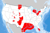 |
Bedded Salt Formation |
Geology |
Oak Ridge National Laboratory |
|
|
Abstract:
The geographic location of possible bedded salt formations in the United States.
Metadata File
Publication Date: 2005 -
Data last updated: 2021-10-26
|
|
 |
Biodiesel Plants |
Utilities |
Energy Information Administration |
|
|
Abstract:
Biodiesel plants of the United States as of May 2015. Source: EIA-22M, Monthly Biodiesel Production Survey.
Metadata File
Publication Date: October 2019 -
Data last updated: 2021-07-15
|
|
 |
Biodiversity (IN) |
Ecology |
IN Department of Natural Resources |
|
|
Abstract:
This layer displays the most efficient subset of areas that satisfy conservation targets, minimizing the footprint of the recommended areas in Indiana.
Metadata File
Data last updated: 2011-09-20
|
|
 |
Biodiversity and Wildlife Habitat Assessment (NC) |
Ecology |
NC Office of Conservation, Planning, and Community Affairs |
|
|
Abstract:
This dataset shows North Carolina's conservation priorities for aquatic and terrestrial species and habitats, and landscape functions and connectivity.
Metadata File
Publication Date: July 2013 -
Data last updated: 2014-10-06
|
|
 |
Biological Hotspot (VT) |
Ecology |
University of Vermont - Spatial Analysis Laboratory |
|
|
Abstract:
Depicts biological "hotspots" in Vermont based on the "element occurrences" in the Non-game and Natural Heritage Program database.
Metadata File
Publication Date: July 2000 -
Data last updated: 2011-09-21
|
|
 |
Biologically Unique Landscape (NE) |
Land Status |
NE Game and Parks Commission |
|
|
Abstract:
This metadata record describes a shapefile depicting Nebraska's Biologically Unique Landscapes (BULs) and one Migratory Bird Landscapes (MBL) as identified in conjunction with the development of a comprehensive wildlife conservation plan (Schneider et al 2005, aka the Natural Legacy Plan, and its subsequent revision in 2010/2011) for the state.
Metadata File
Publication Date: February 2011 -
Data last updated: 2011-09-21
|
|
 |
Block Groups: Low Income |
Demographics |
Census Bureau - American Community Survey |
|
|
Abstract:
Depicts U.S. Census Block Groups with low income and minority statistics from the 2018 American Community Survey (5-Year). Standard environmental justice metrics were computed by Argonne National Laboratory, including percent low income, percent total minority and single race/ethnicity categories, and each percentage minus 20% over the state average of each category.
Metadata File
Publication Date: January 2018 -
Data last updated: 2021-02-23
|
|
 |
Block Groups: Population Density |
Demographics |
Census Bureau - American Community Survey |
|
|
Abstract:
U.S. Census Block Group Population per Square Mile, based on 2018 5-Year American Community Survey estimates.
Metadata File
Publication Date: January 2018 -
Data last updated: 2021-06-07
|
|
 |
Block Groups: Total Minority |
Demographics |
Census Bureau - American Community Survey |
|
|
Abstract:
Depicts U.S. Census Block Groups with low income and minority statistics from the 2018 American Community Survey (5-Year). Standard environmental justice metrics were computed by Argonne National Laboratory, including percent low income, percent total minority and single race/ethnicity categories, and each percentage minus 20% over the state average of each category.
Metadata File
Publication Date: January 2018 -
Data last updated: 2021-02-23
|
|
 |
CNHI: Core Habitat (PA) |
Ecology |
PA Natural Heritage Program - Western PA Conservancy |
|
|
Abstract:
Displays the Core Habitat of Natural Heritage Areas identified through the County Natural Heritage Inventory project of the Pennsylvania Natural Heritage Program. County Natural Heritage Inventories (CNHIs) focus on areas that are the best examples of ecological resources in a county.
Metadata File
Publication Date: December 2010 -
Data last updated: 2011-09-21
|
|
 |
CNHI: Landscape Conservation Area (PA) |
Land Status |
PA Natural Heritage Program - Western PA Conservancy |
|
|
Abstract:
This layer displays the Landscape Conservation Areas (LCA) identified through the County Natural Heritage Inventory project of the Pennsylvania Natural Heritage Program. County Natural Heritage Inventories (CNHIs) focus on areas that are the best examples of ecological resources in a county.
Metadata File
Publication Date: December 2010 -
Data last updated: 2011-09-21
|
|
 |
CNHI: Supporting Landscapes (PA) |
Ecology |
PA Natural Heritage Program - Western PA Conservancy |
|
|
Abstract:
This displays the Supporting Landscapes of Natural Heritage Areas identified through the County Natural Heritage Inventory project of the Pennsylvania Natural Heritage Program. County Natural Heritage Inventories (CNHIs) focus on areas that are the best examples of ecological resources in a county.
Metadata File
Publication Date: December 2010 -
Data last updated: 2011-09-21
|
|
 |
Candidate Landfill Methane Project |
Environmental Hazards |
Environmental Protection Agency |
|
|
Abstract:
This layer displays the candidate landfill gas projects in the United States.
Metadata File
Publication Date: March 2016 -
Data last updated: 2016-11-10
|
|
 |
Census Tract |
Demographics |
Census Bureau |
|
|
Abstract:
This data displays the United States Census Tracts along with population figures from the 2010 Census.
Metadata File
Publication Date: 2010 -
Data last updated: 2019-01-17
|
|
 |
City Boundaries |
Boundary |
Census Bureau |
|
|
Abstract:
Depicts city boundaries from the U.S. Census Bureau. A consolidated city is a unit of local government for which the functions of an incorporated place and its county or minor civil division (MCD) have merged.
Metadata File
Publication Date: January 2023 -
Data last updated: 2024-01-24
|


