|
Thumbnail |
Title |
Category |
Data Source |
Resource |
|
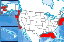 |
Essential Fish Habitat |
Ecology |
National Oceanic and Atmospheric Administration |
|
|
Abstract:
The purpose of these data is to visually represent spatial information for areas in which fishing has been restricted to minimize the adverse effects of fishing to EFH. The spatial extent of these areas will be calculated and used in partial satisfaction of the performance metric reporting requirements of the Habitat Program.
Metadata File
Publication Date: June 2010 -
Data last updated: 2017-01-09
|
|
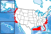 |
Habitats of Particular Concern |
Ecology |
National Oceanic and Atmospheric Administration |
|
|
Abstract:
The purpose of Habitats of Particular Concern is to focus on conservation, management, and research efforts on subsets of Essential Fish Habitat that are vulnerable to degradation or are especially important ecologically for federally managed fish. The Habitats of Particular Concern designation alone does not confer additional protection or restrictions to an area, but helps to focus Essential Fish Habitat conservation, management, and research priorities.
Metadata File
Publication Date: October 2010 -
Data last updated: 2017-01-09
|
|
 |
Ecological risk to sensitive aquatic and riparian species at the HUC12 level due to water use |
Ecology |
Argonne National Laboratory |
|
|
Abstract:
Ecological risk to sensitive aquatic and riparian species at the HUC12 level due to water use
Data last updated: 2022-06-08
|
|
 |
Ecological risk to sensitive aquatic and riparian species at the HUC8 level due to water use |
Ecology |
Argonne National Laboratory |
|
|
Abstract:
Ecological risk to sensitive aquatic and riparian species at the HUC8 level due to water use
Data last updated: 2022-06-08
|
|
 |
WECC Environmental Risk Classes |
Ecology |
Western Electricity Coordinating Council |
|
|
Abstract:
This data set provides environmental risk classes for the Western United States for use in preliminary electricity transmission planning.
Metadata File
Publication Date: October 2015 -
Data last updated: 2016-09-27
|
|
 |
Greater Sage-Grouse General Habitat Management Area Wind Allocations |
Ecology |
Bureau of Land Management |
|
|
Abstract:
This dataset represents the consolidated submissions of Proposed GRSG habitat management areas (General and Important only) from each individual BLM EIS for Tier II analysis.
Metadata File
Publication Date: July 2015 -
Data last updated: 2016-10-10
|
|
 |
Greater Sage-Grouse Priority Habitat Management Area Wind Allocations |
Ecology |
Bureau of Land Management |
|
|
Abstract:
Greater Sage-Grouse Priority Habitat Management Area Wind Allocations
Metadata File
Publication Date: July 2015 -
Data last updated: 2016-10-10
|
|
 |
Sagebrush Focal Areas Wind Allocations |
Ecology |
Bureau of Land Management |
|
|
Abstract:
This dataset is a modified version of the FWS developed data depicting “Highly Important Landscapes”, as outlined in Memorandum FWS/AES/058711 and provided to the Wildlife Habitat Spatial analysis Lab on October 29th 2014.
Metadata File
Publication Date: July 2015 -
Data last updated: 2016-10-20
|
|
 |
Cold-Water Coral Habitat |
Ecology |
Geological Survey |
|
|
Abstract:
The USGS Cold-Water Coral Geographic Database (CoWCoG) provides a tool for researchers and managers interested in studying, protecting, and/or utilizing cold- water coral habitats in the Gulf of Mexico and western North Atlantic Ocean.
Metadata File
Publication Date: 2010 -
Data last updated: 2013-04-08
|
|
 |
Landscape v3.1 - Atlantic Coastal Region (NJ) |
Ecology |
NJ Department of Environmental Protection - Division of Fish and Wildlife |
|
|
Abstract:
Displays the Landscape Project which combines documented wildlife locations with NJDEP aerial photo-based 2007 Land Use/Land Cover (LULC) to delineate imperiled and special concern species habitat within New Jersey within Atlantic Coastal Region.
Metadata File
Publication Date: 2012 -
Data last updated: 2012-07-19
|
|
 |
Landscape v3.1 - Marine Region (NJ) |
Ecology |
NJ Department of Environmental Protection - Division of Fish and Wildlife |
|
|
Abstract:
Displays the Landscape Project which combines documented wildlife locations with NJDEP aerial photo-based 2007
Land Use/Land Cover (LULC) to delineate imperiled and special concern species habitat within New Jersey within the
Marine Region.
Metadata File
Publication Date: 2012 -
Data last updated: 2012-07-19
|
|
 |
NHESP BioMap2 Core Habitat |
Ecology |
MA Division of Fisheries and Wildlife; et al. |
|
|
Abstract:
This layer displays lands important to the protection of: Habitats for rare, vulnerable, or uncommon vertebrate, invertebrate, and plants species; Priority natural communities; High-quality wetland, vernal pool, aquatic, and coastal habitats; and intact forest ecosystems in Massachusetts.
Metadata File
Publication Date: 2010 -
Data last updated: 2012-06-08
|
|
 |
Coastal Critical Habitat |
Ecology |
National Oceanic and Atmospheric Administration |
|
|
Abstract:
This dataset is a compilation of the NOAA National Marine Fisheries Service and the U.S. Fish & Wildlife Service ESA listed species in coastal areas.
Metadata File
Data last updated: 2018-08-15
|
|
 |
Greater Sage-Grouse General Habitat Management Area Solar Allocations |
Ecology |
Bureau of Land Management |
|
|
Abstract:
This dataset represents the consolidated submissions of Proposed GRSG habitat management areas (General and Important only) from each individual BLM EIS for Tier II analysis.
Metadata File
Publication Date: July 2015 -
Data last updated: 2016-10-24
|
|
 |
Crucial Habitat Assessment Tool (CHAT) |
Ecology |
Western Association of Fish and Wildlife Agencies |
|
|
Abstract:
This dataset represents an aggregated measure of crucial habitat for species of interest to the western states' fish and wildlife management agencies.
Metadata File
Publication Date: February 2016 -
Data last updated: 2019-01-17
|


