|
Thumbnail |
Title |
Category |
Data Source |
Resource |
|
 |
Tight Oil/Shale Gas Play |
Geology |
Energy Information Administration |
|
|
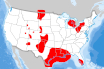
Abstract:
Tight oil and shale gas plays in the Lower 48 States. Source: U.S. Energy Information Administration based on data from various published studies. Updated March 2019.
Metadata File
Publication Date: March 2019 -
Data last updated: 2019-05-20
|
|
 |
Coal Mine/Facility |
Geology |
Energy Information Administration |
|
|
Abstract:
Operating surface and underground coal mines in the United States as of 2018.
Metadata File
Publication Date: January 2020 -
Data last updated: 2020-10-15
|
|
 |
Oil and Natural Gas Fields |
Geology |
Homeland Infrastructure Foundation Level Database (HIFLD) |
|
|
Abstract:
Oil and Natural Gas Fields for the Homeland Infrastructure Foundation-Level (HIFLD) Database (https://hifld-dhsgii. gov/HIFLD) as well as the Energy modeling and simulation community.
Metadata File
Publication Date: August 2017 -
Data last updated: 2021-08-12
|
|
 |
Sedimentary Basins with Shale Plays |
Geology |
Energy Information Administration |
|
|
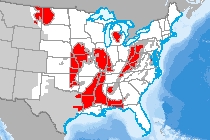
Abstract:
Sedimentary basins associated with the EIA shale plays as of 5-6-2011. Sedimentary basin which do not have shale plays as of publication date are not included in this file. Sources for the basins are mostly from the US Geological Survey and state agencies such as the WY Geological Survey.
Metadata File
Publication Date: May 2011 -
Data last updated: 2020-10-15
|
|
 |
Seismic Risk (2% in 50 years) |
Geology |
Geological Survey |
|
|
Abstract:
Depicts risk of seismic peak horizontal ground acceleration (the fastest measured change in speed, for a particle at ground level that is moving horizontally due to an earthquake) with a 2% probability of exceedance in 50 years. Values are given in %g, where g is acceleration due to gravity, or 9.8 meters/second^2. The lines of equal hazard, which are the lines between the polygons, were determined by interpolating from a grid of equally spaced points in latitude and longitude. Each point was weighted based on the seismic hazard at that location. The grid spacing is 0.1 degrees for Alaska, 0.05 degrees for the conterminous United States, and 0.02 degrees for Hawaii.
Metadata File
Publication Date: January 2021 -
Data last updated: 2022-06-08
|
|
 |
Seafloor Geology |
Geology |
Geological Survey |
|
|
Abstract:
Displays the grain size of seafloor sediments.
Metadata File
Publication Date: 2005 -
Data last updated: 2012-07-18
|
|
 |
Bedded Salt Formation |
Geology |
Oak Ridge National Laboratory |
|
|
Abstract:
The geographic location of possible bedded salt formations in the United States.
Metadata File
Publication Date: 2005 -
Data last updated: 2021-10-26
|
|
 |
Coalbed Methane Field |
Geology |
Energy Information Administration |
|
|
Abstract:
This dataset is field boundary polygons of Coalbed Methane (CBM) based on producing wells in the USA. Field outline polygons were created by buffering wells from each field. Buffered well polygons from each field were then unioned into a single polygon record (may contain multiple rings). A smoothing algorithm was applied to the polygons.
Metadata File
Publication Date: August 2007 -
Data last updated: 2019-05-10
|
|
 |
Domal Salt Formation |
Geology |
Oak Ridge National Laboratory |
Storage |
|
Abstract:
The geographic location of possible domal salt formations in the United States.
Metadata File
Data last updated: 2013-02-01
|
|
 |
Enhanced Geothermal System (EGS) Potential |
Geology |
National Renewable Energy Laboratory |
|
|
Abstract:
This dataset is a qualitative assessment of geothermal potential (Enhanced Geothermal System EGS) for the US based on Levelized Cost of Electricity, with CLASS 1 being most favorable, and CLASS 5 being least favorable. This dataset does not include shallow EGS resources located near hydrothermal sites or USGS assessment of undiscovered hydrothermal resources.
Metadata File
Publication Date: 2009 -
Data last updated: 2022-06-13
|
|
 |
Estimated Temperature at 2000 m Depth |
Geology |
National Renewable Energy Laboratory |
|
|
Abstract:
Estimated temperature at 2000 m Depth
Metadata File
Publication Date: 2016 -
Data last updated: 2021-07-22
|
|
 |
Geologic Survey Map |
Geology |
Geological Survey |
|
|
Abstract:
The open-file report presents the results of the USGS Mineral Resources Program activity to compile a national-scale geologic map database to support national and regional level projects, including mineral resource and geo- environmental assessments.
Metadata File
Publication Date: 2005 -
Data last updated: 2011-09-09
|
|
 |
Geopressure Energy Potential - Plan 2 |
Geology |
National Renewable Energy Laboratory |
Geothermal |
|
Abstract:
Plan 2 - Geopressurized resource data from USGS 1978 Circular, "Assessment of Geothermal Resources of the United States." Layer represents producible energy over 30 years in MWe/km^2 with a 2.6% recovery factor from total thermal energy.
Metadata File
Publication Date: 1978 -
Data last updated: 2012-08-11
|
|
 |
Geopressure Energy Potential - Plan 3 |
Geology |
National Renewable Energy Laboratory |
Geothermal |
|
Abstract:
Plan 3 - Geopressurized resource data from USGS 1978 Circular, "Assessment of Geothermal Resources of the United States." Layer represents producible energy over 30 years in MWe/km^2 with a 0.25% recovery factor from total thermal energy.
Metadata File
Publication Date: 1978 -
Data last updated: 2012-08-11
|
|
 |
Geothermal Favorability (Western US) |
Geology |
Geological Survey |
|
|
Abstract:
This is intended to highlight areas of elevated potential for the presence of undiscovered moderate (90 - 150° C) to high (> 150° C) temperature geothermal systems. It is not meant to be used to locate exact areas for exploration.
Metadata File
Publication Date: December 2008 -
Data last updated: 2019-09-23
|


