|
Thumbnail |
Title |
Category |
Data Source |
Resource |
|
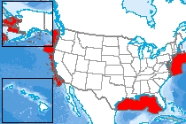 |
Essential Fish Habitat |
Ecology |
National Oceanic and Atmospheric Administration |
|
|
Abstract:
The purpose of these data is to visually represent spatial information for areas in which fishing has been restricted to minimize the adverse effects of fishing to EFH. The spatial extent of these areas will be calculated and used in partial satisfaction of the performance metric reporting requirements of the Habitat Program.
Metadata File
Publication Date: June 2010 -
Data last updated: 2017-01-09
|
|
 |
Enhanced Geothermal System (EGS) Technology Potential |
Geology |
National Renewable Energy Laboratory |
|
|
Abstract:
This dataset reflects power density estimate at optimum LCOE between 3.5 and 9.5 km. Levelized Cost of Electricity (LCOE) was calculated for Temperature at Depth (TAD) data, which was produced by the Southern Methodist University (SMU) geothermal program. TAD data for the lower 48 United States, which estimated temperature at depth from 3.5 km to 9.5 km in 1 km intervals.
Metadata File
Data last updated: 2017-01-19
|
|
 |
Enhanced Geothermal System (EGS) Potential |
Geology |
National Renewable Energy Laboratory |
|
|
Abstract:
This dataset is a qualitative assessment of geothermal potential (Enhanced Geothermal System EGS) for the US based on Levelized Cost of Electricity, with CLASS 1 being most favorable, and CLASS 5 being least favorable. This dataset does not include shallow EGS resources located near hydrothermal sites or USGS assessment of undiscovered hydrothermal resources.
Metadata File
Publication Date: 2009 -
Data last updated: 2022-06-13
|
|
 |
Energy Potential Non-Powered Dam |
Utilities |
Oak Ridge National Laboratory |
|
|
Abstract:
This layer was created to assess the energy potential at non-powered dams (NPDs) throughout the United States.
Metadata File
Publication Date: 2012 -
Data last updated: 2016-11-02
|
|
 |
Elevation Range (Sea Level Rise Predictions - 2100) |
Landform |
Geological Survey, Argonne National Laboratory |
|
|
Abstract:
This layer was made using USGS digital elevation data categorized into elevation ranges for predicted 2100 levels of sea level rise in the 2014 U.S. National Climate Assessment (NCA) report. From the NCA, p. 45: "The future scenarios range from 0.66 feet to 6.6 feet in 2100. These scenarios are not based on climate model simulations, but rather reflect the range of possible scenarios based on other scientific studies.
Metadata File
Publication Date: 2009 -
Data last updated: 2015-05-29
|
|
 |
Electrical Substations |
Utilities |
Homeland Infrastructure Foundation Level Database (HIFLD) |
|
|
Abstract:
Depicts electric power substations primarily associated with electric power transmission. In this layer, substations are considered facilities and equipment that switch, transform, or regulate electric power at voltages equal to, or greater than, 69 kilovolts. Substations with a maximum operating voltage less than 69 kilovolts may be included, depending on the availability of authoritative sources, but coverage of these features should not be considered complete. The layer includes taps, where power on a transmission line is tapped by another transmission line.
Metadata File
Publication Date: April 2022 -
Data last updated: 2022-06-08
|
|
 |
Electrical Power Plant Capacity |
Utilities |
Environmental Protection Agency - eGRID |
|
|
Abstract:
This layer displays electrical power plants in the United States.
Metadata File
Publication Date: 2012 -
Data last updated: 2016-12-14
|
|
 |
Electric Vehicle Charging Stations (Tesla Level 2) |
Transportation |
Alternative Fuels Data Center |
|
|
Abstract:
Depicts Tesla brand Level 2 electric vehicle charging stations from the Alternative Fueling Stations dataset as of November 8, 2023.
Metadata File
Publication Date: November 2023 -
Data last updated: 2023-11-10
|
|
 |
Electric Vehicle Charging Stations (Tesla DC Fast) |
Transportation |
Alternative Fuels Data Center |
|
|
Abstract:
Depicts Tesla brand DC Fast electric vehicle charging stations from the Alternative Fueling Stations dataset as of November 8, 2023.
Metadata File
Publication Date: November 2023 -
Data last updated: 2023-11-10
|
|
 |
Electric Vehicle Charging Stations (Planned) |
Transportation |
Alternative Fueld Data Center |
|
|
Abstract:
Depicts planned electric vehicle charging stations from the Alternative Fueling Stations dataset as of November 8, 2023.
Metadata File
Publication Date: November 2023 -
Data last updated: 2023-11-10
|
|
 |
Electric Vehicle Charging Stations (Non-Tesla Level 2) |
Transportation |
Alternative Fuels Data Center |
|
|
Abstract:
Depicts non-Tesla brand Level 2 electric vehicle charging stations from the Alternative Fueling Stations dataset as of November 8, 2023.
Metadata File
Publication Date: November 2023 -
Data last updated: 2023-11-10
|
|
 |
Electric Vehicle Charging Stations (Non-Tesla DC Fast) |
Transportation |
Alternative Fuels Data Center |
|
|
Abstract:
Depicts non-Tesla brand DC Fast electric vehicle charging stations from the Alternative Fueling Stations dataset as of November 8, 2023.
Metadata File
Publication Date: November 2023 -
Data last updated: 2023-11-10
|
|
 |
Electric Power Retail Service Territories |
Utilities |
Homeland Infrastructure Foundation Level Database (HIFLD) |
|
|
Abstract:
Depicts electric power retail service territories. These are areas serviced by electric power utilities responsible for the retail sale of electric power to local customers, whether residential, industrial, or commercial.
Metadata File
Publication Date: July 2020 -
Data last updated: 2021-06-03
|
|
 |
Electric Planning Areas |
Utilities |
Homeland Infrastructure Foundation Level Database (HIFLD) |
|
|
Abstract:
This feature class/shapefile represents electric power planning areas. The area covered by those entities which are responsible for the coordination, integration, and long-term planning of transmission operations within their region, often comprised of the retail service territories of numerous electric power utilities.
Metadata File
Publication Date: July 2020 -
Data last updated: 2021-08-25
|
|
 |
Ecoregional Portfolio |
Ecology |
The Nature Conservancy |
|
|
Abstract:
This dataset provides a vision for conservation success for ecosystems, natural communities and species representative of an ecoregion by showing the boundaries of areas that The Nature Conservancy has prioritized for conservation. Many portfolio areas were derived from Ecoregional Assessments, but other priorities derived using other planning methodologies are included in this global dataset.
Metadata File
Publication Date: December 2011 -
Data last updated: 2014-04-03
|


