|
Thumbnail |
Title |
Category |
Data Source |
Resource |
|
 |
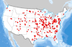
Clean Cities Coalition Boundaries |
Transportation |
Clean Cities |
|
|
Abstract:
Depicts Clean City Coalition Boundaries
Metadata File
Publication Date: November 2023 -
Data last updated: 2023-11-10
|
|
 |
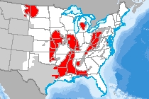
Climate and Economic Justice Screening Tool v1.0 (Climate) |
Demographics |
Council on Environmental Quality |
|
|
Abstract:
Climate: Depicts census tracts symbolized with equity factors from the Climate and Economic Justice Screening Tool (v1.0). Communities are identified as disadvantaged for climate change if there are at or above the 90th percentile for expected agriculture loss rate OR expected building loss rate OR expected population loss rate OR projected flood risk OR projected wildfire risk AND are at or above the 65th percentile for low income.
Metadata File
Publication Date: January 2024 -
Data last updated: 2024-02-23
|
|
 |
Climate and Economic Justice Screening Tool v1.0 (Energy) |
Demographics |
Council on Environmental Quality |
|
|
Abstract:
Energy: Depicts census tracts symbolized with equity factors from the Climate and Economic Justice Screening Tool (v1.0). Communities are identified as disadvantaged for energy if they are in census tracts that are at or above the 90th percentile for energy cost OR PM2.5 in the air AND are at or above the 65th percentile for low income.
Metadata File
Publication Date: January 2024 -
Data last updated: 2024-02-23
|
|
 |
Climate and Economic Justice Screening Tool v1.0 (Transportation) |
Demographics |
Council on Environmental Quality |
|
|
Abstract:
Transportation: Depicts census tracts symbolized with equity factors from the Climate and Economic Justice Screening Tool (v1.0). Communities are identified as disadvantaged for transportation if they are in census tracts that are at or above the 90th percentile for diesel particulate matter exposure OR transportation barriers OR traffic proximity and volume AND are at or above the 65th percentile for low income.
Metadata File
Publication Date: January 2024 -
Data last updated: 2024-02-23
|
|
 |
Climate and Economic Justice Screening Tool v1.0 (Water) |
Demographics |
Council on Environmental Quality |
|
|
Abstract:
Water and wastewater: Depicts census tracts symbolized with equity factors from the Climate and Economic Justice Screening Tool (v1.0). Communities are identified as disadvantaged for water and wastewater if they are in census tracts that are at or above the 90th percentile for underground storage tanks and releases OR wastewater discharge AND are at or above the 65th percentile for low income.
Metadata File
Publication Date: January 2024 -
Data last updated: 2024-02-23
|
|
 |
Coal Basins, Region, and Field |
Geology |
Geological Survey |
Coal |
|
Abstract:
This data set shows the coal fields of Alaska and the conterminous United States.
Metadata File
Publication Date: February 2012 -
Data last updated: 2021-09-28
|
|
 |
Coal Mine/Facility |
Geology |
Energy Information Administration |
|
|
Abstract:
Operating surface and underground coal mines in the United States as of 2018.
Metadata File
Publication Date: January 2020 -
Data last updated: 2020-10-15
|
|
 |
Coal Plants Suitable for Co-Firing Biomass |
Utilities |
Environmental Protection Agency - eGRID |
|
|
Abstract:
This layer displays Coal Plants Suitable for Co-Firing Biomass in the United States.
Metadata File
Publication Date: February 2021 -
Data last updated: 2021-10-12
|
|
 |
Coalbed Methane Field |
Geology |
Energy Information Administration |
|
|
Abstract:
This dataset is field boundary polygons of Coalbed Methane (CBM) based on producing wells in the USA. Field outline polygons were created by buffering wells from each field. Buffered well polygons from each field were then unioned into a single polygon record (may contain multiple rings). A smoothing algorithm was applied to the polygons.
Metadata File
Publication Date: August 2007 -
Data last updated: 2019-05-10
|
|
 |
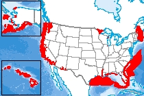
Coastal Barrier Resources System |
Hydrography |
Fish and Wildlife Service |
|
|
Abstract:
This layer displays the aerial extent of the boundaries of the John H. Chafee Coastal Barrier Resources System.
Metadata File
Publication Date: May 2015 -
Data last updated: 2015-07-21
|
|
 |
Coastal Critical Habitat |
Ecology |
National Oceanic and Atmospheric Administration |
|
|
Abstract:
This dataset is a compilation of the NOAA National Marine Fisheries Service and the U.S. Fish & Wildlife Service ESA listed species in coastal areas.
Metadata File
Data last updated: 2018-08-15
|
|
 |
Cold-Water Coral Habitat |
Ecology |
Geological Survey |
|
|
Abstract:
The USGS Cold-Water Coral Geographic Database (CoWCoG) provides a tool for researchers and managers interested in studying, protecting, and/or utilizing cold- water coral habitats in the Gulf of Mexico and western North Atlantic Ocean.
Metadata File
Publication Date: 2010 -
Data last updated: 2013-04-08
|
|
 |
College/University |
Buildings |
Argonne National Laboratory |
|
|
Abstract:
This layer displays Colleges and Universities in the United States.
Metadata File
Data last updated: 2012-04-23
|
|
 |
Commericial Nuclear Power Plant |
Utilities |
Environmental Protection Agency |
|
|
Abstract:
This dataset represents nuclear power plants from the U.S. EPA Emissions & Generation Resource Integrated Database (eGRID2012).
Metadata File
Publication Date: October 2015 -
Data last updated: 2016-12-13
|
|
 |
Congressional Districts - 118th Congress |
Boundary |
U.S. Census Bureau |
|
|
Abstract:
Depicts 118th U.S. Congress district boundaries.
Metadata File
Publication Date: January 2023 -
Data last updated: 2024-01-05
|


