|
Thumbnail |
Title |
Category |
Data Source |
Resource |
|
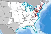 |
River Temperature Model (NE) |
Climate |
City University of New York |
|
|
Abstract:
This dataset depicts modeling results from the Water Balance Model-Thermoelectric Power & Thermal Pollution Model (WBM-TP2M) for the northeast U.S. Together, these models incorporate climate, hydrology, river network dynamics and multi-plant impacts to quantify the following on a per power plant basis and at a regional scale:
• Thermal pollution
• Electricity generation
• Water withdrawal and consumption
• River temperatures and discharge
• Power plant efficiency losses associated with changes in available cooling water and climate conditions
Results here show monthly average temperature changes due to power plant thermal effluents for years 2000 – 2010 Rivers shown have a modeled average summertime discharge of 5 cubic meters/second and higher for the years 2000 – 2010. Temperature changes are given in degrees Celsius and results were computed at a daily time steps and a 5 km cell spatial resolution.
Metadata File
Publication Date: July 2015 -
Data last updated: 2015-09-02
|
|
 |
River Opportunity Area (WI) |
Ecology |
Wisconsin Department of Natural Resources - Bureau of Endangered Resources |
|
|
Abstract:
Displays river system conservation opportunity areas in Wisconsin.
Metadata File
Publication Date: June 2008 -
Data last updated: 2011-09-21
|
|
 |
Ridgeline Area |
Landform |
National Renewable Energy Laboratory |
|
|
Abstract:
This data, developed at the National Renewable Energy Laboratory, represents ridgelines across the United States at a 1km spatial resolution.
Metadata File
Data last updated: 2016-03-22
|
|
 |
Renewable Energy Leasing Area - New Jersey |
Climate |
Bureau of Ocean Energy Management |
|
|
Abstract:
New Jersey Wind Energy Area (WEA) lease block area which will go up for auction November 9th, 2015. The New Jersey WEA will be auctioned as two leases (OCS-A 0498 and OCS-A 0499).
Metadata File
Publication Date: 2015 -
Data last updated: 2015-10-21
|
|
 |
Renewable Energy Leasing Area |
Climate |
Bureau of Ocean Energy Management |
|
|
Abstract:
This layer displays active renewable energy leasing areas on the Atlantic Outer Continental Shelf (OCS).
Metadata File
Publication Date: March 2016 -
Data last updated: 2016-04-04
|
|
 |
Rare, Threatened, and Endangered Species and Significant Community (VT) |
Ecology |
Vermont Fish and Wildlife Department - Nongame and Natural Heritage Program |
|
|
Abstract:
Displays rare, threatened and endangered species and natural (plant) communities in Vermont.
Metadata File
Publication Date: April 2015 -
Data last updated: 2015-08-27
|
|
 |
Rare Species (MA) |
Ecology |
MA Division of Fisheries and Wildlife; et al. |
|
|
Abstract:
This layer depicts the Priority Habitats of Rare Species. Data layer contains polygons representing the geographic extent of Habitat of state-listed rare species in Massachusetts based on observations
documented within the last 25 years in the database of the Natural Heritage & Endangered Species Program (NHESP).
Metadata File
Publication Date: September 2008 -
Data last updated: 2011-09-21
|
|
 |
Railroads |
Transportation |
Federal Railroad Administration |
|
|
Abstract:
Depicts the railway system in the United States (1:100,000) scale.
Metadata File
Publication Date: October 2023 -
Data last updated: 2023-11-30
|
|
 |
Quaternary Fault |
Geology |
Geological Survey |
|
|
Abstract:
Depicts faults and associated folds in the that are believed to be sources of M>6 earthquakes during the Quaternary (the past 1,600,000 years).
Metadata File
Publication Date: 2020 -
Data last updated: 2021-12-15
|
|
 |
Pumped Storage Site |
Hydrography |
Sandia National Laboratories |
Storage |
|
Abstract:
Depicts pumped storage facility locations throughout the United States.
Metadata File
Publication Date: October 2016 -
Data last updated: 2016-11-22
|
|
 |
Pumped Storage Pending Preliminary Permit |
Hydrography |
Federal Energy Regulatory Commission |
Storage |
|
Abstract:
Pending preliminary permits for pumped storage projects by the Federal Energy Regulatory Commission. Preliminary permits are issued for up to three years, and do not authorize construction; rather, it maintains priority of application for a license (i.e., guaranteed first-to-file status) while the permittee studies the site and prepares to apply for a license. The permittee must submit periodic reports on the status of its studies. It is not necessary to obtain a permit in order to apply for or receive a license.
Metadata File
Publication Date: November 2011 -
Data last updated: 2011-11-14
|
|
 |
Pumped Storage Issued Preliminary Permit |
Hydrography |
Federal Energy Regulatory Commission |
Storage |
|
Abstract:
Issued preliminary permits for pumped storage projects by the Federal Energy Regulatory Commission. Preliminary permits are issued for up to three years, and do not authorize construction; rather, it maintains priority of application for a license (i.e., guaranteed first-to-file status) while the permittee studies the site and prepares to apply for a license. The permittee must submit periodic reports on the status of its studies. It is not necessary to obtain a permit in order to apply for or receive a license.
Metadata File
Publication Date: November 2011 -
Data last updated: 2011-11-14
|
|
 |
Public Transit Stop Density |
Transportation |
National Neighborhood Data Archive (NaNDA) |
|
|
Abstract:
Depicts the number of public transit stops per United States census tract based on data from the National Transit Map (NTM). Each observation represents the count and density (per capita and square mile) of transit stops within a census tract, as voluntarily reported to NTM between 2016 and 2018 by one of 270 regional transit agencies choosing to participate.
Metadata File
Publication Date: April 2019 -
Data last updated: 2021-10-12
|
|
 |
Public Land Survey System - Townships |
Cadastre |
Bureau of Land Management |
|
|
Abstract:
Depicts Public Land Survey System Townships.
Metadata File
Publication Date: September 2023 -
Data last updated: 2024-01-08
|
|
 |
Public Land Survey System - Sections |
Cadastre |
Bureau of Land Management |
|
|
Abstract:
Depicts Public Land Survey System Sections.
Metadata File
Publication Date: September 2023 -
Data last updated: 2024-01-08
|


